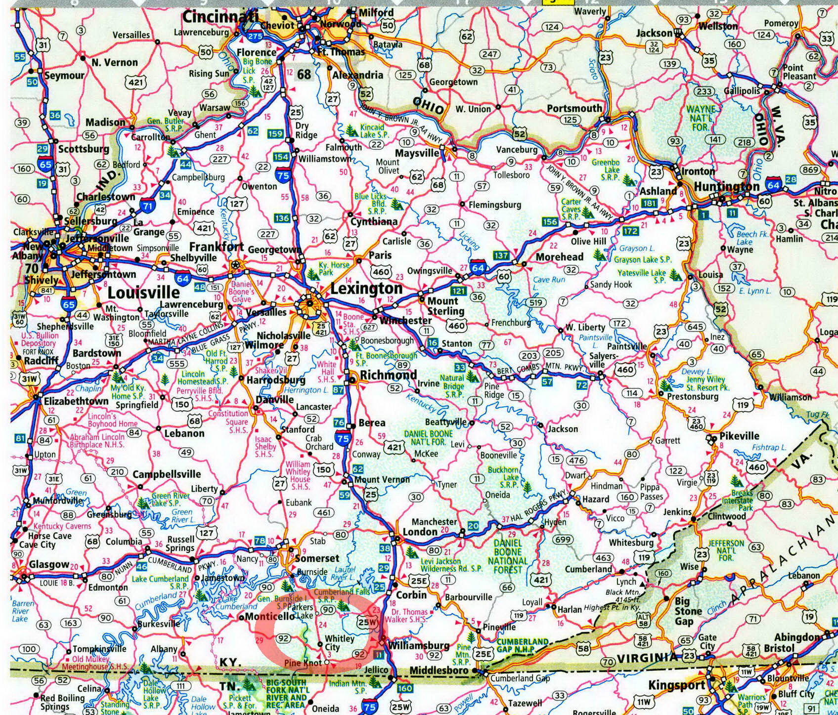
Alum Ford Campground in Kentucky on map

Alum Ford Campground
Camp on the Big South Fork near Kentucky's highest waterfall.
When I was inquiring with the park service about Alum Ford, the voice on the other line stated, "You might not like it. That place is primitive." She didn't know she was talking to a tent camper who likes his campgrounds that way! Upon my arrival in person, Alum Fork did not disappoint. It was primitive. Located near a boat landing on the Big South Fork, the campground was strung along a dead-end gravel road on the edge of the river gorge. What made it even better were all the recreational opportunities nearby—hiking, boating, fishing, and swimming.
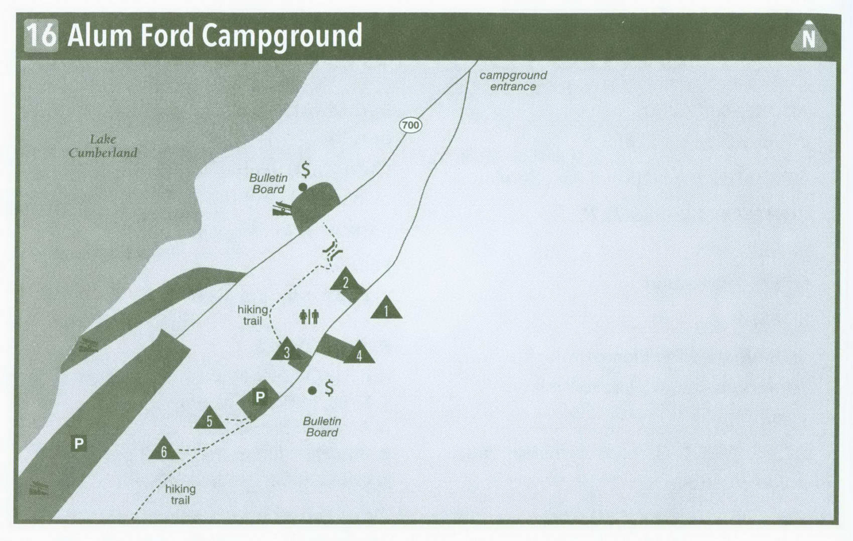
But first, the campground. Be watchful along the road to Alum Ford landing, for the road to the campground, cut into the side of the hill, spurs unexpectedly to the left just before reaching the Big South Fork of the Cumberland River. After passing a wet-weather stream, you begin to wonder where the campground is going to be in this forest of tall, smooth beech trees, shaggy hickories, and upright oaks. Crane your neck and look left, up the steep hill to campsite 1. Steps have been cut into the hillside here, leading to a platform where campers look out on the forest. Site 2 is on the right-hand side of the road, closer to the river. It is downslope of the gravel road, as is site 3. The next one, 4, is up the hill on the left.
Pass the pay station and bulletin board. On your right, the bluff is so steep that the park service has erected a fence to keep careless campers from taking an unintended tumble to the river. Campers who stay at 5 and 6 have to park here and walk a bit to reach their sites, the most secluded in the campground. But how much seclusion do you need at a place with only six campsites? Alum Ford rarely fills, save for holiday weekends.
All the sites are wooded, but there are obscured views of the river below and a tall rock bluff on the far side of the gorge. Shade will be welcome during the hot summer months. But if you get too hot, the river is just a 5-minute walk down a footpath, so don't take the quick route over the bluff. Swimmers can enjoy the landing at Alum Ford. The upper reaches of Lake Cumberland extend to Alum Ford, making for a slack or minimal current most of the time. Bring your canoe or small boat. Paddling enthusiasts can also explore the waters here, fishing for smallmouth bass and sunfish. If you want more exciting water, head upstream and run the Big South Fork gorge, starting at Worley or Yamacraw; then ease your way down to Alum Ford. It is mostly Class I
or II rapids; although, when Lake Cumberland isn't at full pool, the rapids are flooded and thus eliminated. However, a good trip is from Blue Heron to Yamacraw, offering Class II water.
Hikers have a special treat here. The master path of Kentucky, the 280-mile Sheltowee Trace, passes right through the campground on the gravel road, marked by the turtle blaze on the trees. Head north on the Sheltowee 1.3 miles along the river to reach the Yahoo Falls Scenic Area. Here, a group of trails takes you all through this special slice of the Big South Fork. Walk a short distance to Yahoo Falls, Kentucky's highest at 113 feet. Here, a veil of water spills over a lip of rock into a pool that lies in the amphitheater of an immense rockhouse where American Indians resided more than 9,000 years ago. Hikers who trek south from Alum Ford can enjoy big boulders, small falls, and rockhouses. A trail shelter and old homesite are 1.4 miles south on the Trace. Reach Princess Falls after 4 miles; it is just a short distance up the Lick Creek Trail, which meets the Shel-towee Trace. The beauty and recreation opportunities of this area are obviously much larger than the intimate Alum Ford campground.
Getting to Alum Ford Campground
From Exit 11 on I-75 near Williamsburg, head west on KY 92 20 miles to US 27. Turn right on US 27 and follow it 6.5 miles north to KY 700. Turn left on KY 700 and follow it 5.5 miles to the Alum Ford fee station. Veer left onto the gravel campground road just before reaching a boat ramp on the Big South Fork River.
GPS COORDINATES N36° 45.832' W84° 32.796'
Key Information about Alum Ford Campground
ADDRESS: KY 700, Whitley City, KY 42653
OPERATED BY: National Park Service
CONTACT: 423-286-7275; nps.gov/biso
OPEN: Year-round
SITES: 6
SITE AMENITIES: Picnic table, fire ring, lantern post, tent pad; some have upright grills
ASSIGNMENT: First come, first served; no reservations
REGISTRATION: Self-registration on-site
FACILITIES: Vault toilets (bring your own water)
PARKING: At campsites only FEE:$5
ELEVATION: 800 feet
RESTRICTIONS in Alum Ford Campground
¦ Pets: On 6-foot leash only
¦ Fires: In fire rings only
¦ Alcohol: Prohibited
¦ Vehicles: No more than 2 per site
¦ Other: 14-day stay limit
